|
 A couple of years ago one of our members came across a rare document which took us all by surprise. A couple of years ago one of our members came across a rare document which took us all by surprise.
We think we know the history of an area quite well then along comes something which shows just how little we really know and how much there is still to find out.
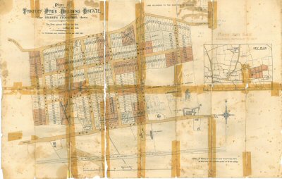
What turned up in this instance was a map showing proposed development of an area in quite fine detail. The area that it shows is the site that has just been developed in the last few years as Priors Green. This lies between the main Stortford to Dunmow road (the Roman Staine Street) and the ancient Jacks Lane (a double ditched track whcih may even predate the Romans). Prior to development most of this site had been fields and woodland for as far back as anyone alive today could remember.
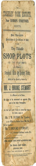
It was therefore a great surprise to find a map showing the area split into hundreds of separate plots for sale dated 1904 ! This sale was to have been a big event. Special trains were to run from Liverpool Street to Takeley Station each sale day (dates to be announced in national newspapers) with luncheon provided in the auction marquee. The development was to be called Takeley Park Estate. If this had gone ahead it would have been a very different development compared to the current Prior’s Green. The typical housing plot (or villa as they were described on the map) were 16ft wide by 150ft long (that’s over 5m by 50m). Shops would have lined the main road.
Why it didn’t go ahead is a mystery. Presumably too few people were interested in buying the plots to justify properly developing the roads. Some houses were built in this area around the 1920s/1930s but they did not follow the layout of the long narrow plots. However, the legacy of this plan is that several of the roads now in place appear on it. In maps from 1898 there are no roads shown, only footpaths, but by 1923 the outlines of the roads are there as shown on the sale map. The names Warwick Road, Hamilton Road and Thornton Road all come from this plan.
 Click on the maps to open the large .pdf files Click on the maps to open the large .pdf files
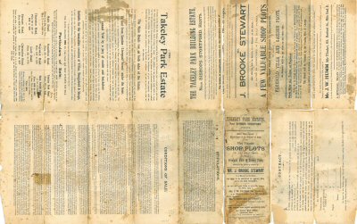
As far as we know this is the only surviving copy of the map and as is often the case with large, old, folded maps it has become somewhat frail over the years and picked up more than its fair share of sticky tape. However, we have managed to scan it sand clicking on the images above will download pdf versions of teh map which can be examined in close detail.
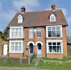
Finally, the picture below shows a pair of fine Takeley houses built in 1905 which are a very good example of what would have been built had this plan gone ahead.
|